Weather (WX).
The weather system that's built into EasyVFR 4 is designed to provide you with the optimal weather information and a minimum of hassle. The weather can be downloaded as often as you like at no extra charge and can be displayed on the Moving Map, used in flight planning, and to provide you with detailed weather briefings for either a single location or your entire planned route.
Weather System.
Weather data can be downloaded via Status card (select the red/amber/green Status dot in the bottom row second from right) -> Data, also the current "age" of the weather data can be verified there.
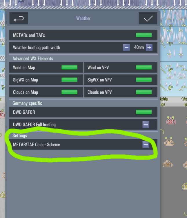
Weather settings are accessible via Map layer (right vertical row second from top) -> Weather.
- WX on the Moving Map.
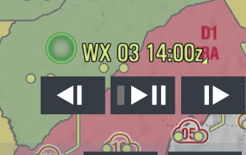
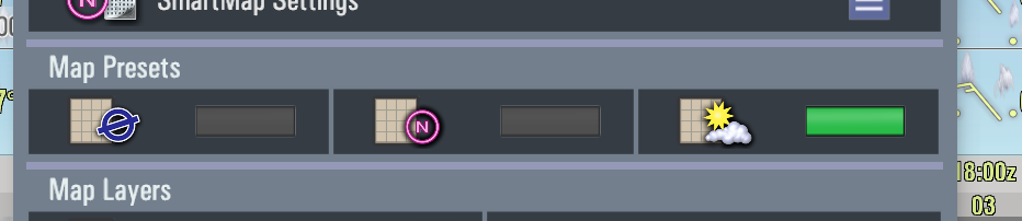
Having the weather displayed on the Moving Map is very convenient in-flight. Is that puff of clouds you see outside perhaps the prelude of something nastier? When you switch to the Weather map preset EasyVFR 4 will switch to a map display showing all relevant weather information. Using the Weather TimeStepper you can set the date and time of the weather symbols you'd like to see on the map. You can move forward as far as 48 hours in the future to view development.
The METAR TAF button toggles the display of the colored circles around airports. A solid circle means the information is based on a METAR (tip: solid line = solid info), a dotted circle means it's taken from a TAF. By default, the color code is computed based on visibility and cloud base according to the NATO standard:
Color | Visibility and/or | Cloud base |
Blue | 8 km or more | 2500' or higher |
White | 5 to 8 km | 1500' to 2500' |
Green | 3.7 to 5 km | 700' to 1500' |
Yellow | 1.6 to 3.7 km | 300' to 700' |
Amber | 0.8 to 1.6 km | 200' to 300' |
Red | 800 m or less | 200' or lower |
However, via the Colour Coding control you can also select GAFOR:

Color | Visibility and/or | Cloud base |
Blue (Clear) | 10 km or more | 5000' or higher |
Green (Open) | 8 to 10 km | 2000' to 5000' |
Yellow (Difficult) | 5 to 8 km | 1000' to 2000' |
Amber (Marginal) | 1.5 to 5 km | 500' to 1000' |
Red (X - Closed) | 1.5 km or less | 500' or lower |
and OrbiFly coding:

Color | Visibility and/or | Cloud base |
Green (VFR) | 8 km or more | 3000' or higher |
Blue (Marginal VFR) | 5 to 8 km | 1000' to 3000' |
Amber (IFR) | 1.5 to 5 km | 500' to 1000' |
Pink (Intense IFR) | 800 to 1500 m | 200' to 500' |
Red (Full IFR) | 800 m or less | 200' or lower |
Since yellow, amber and red (or amber, pink and yellow with OrbiFly) are generally considered not to be VFR conditions, you can see at a glance whether or not an airport's weather is suitable.
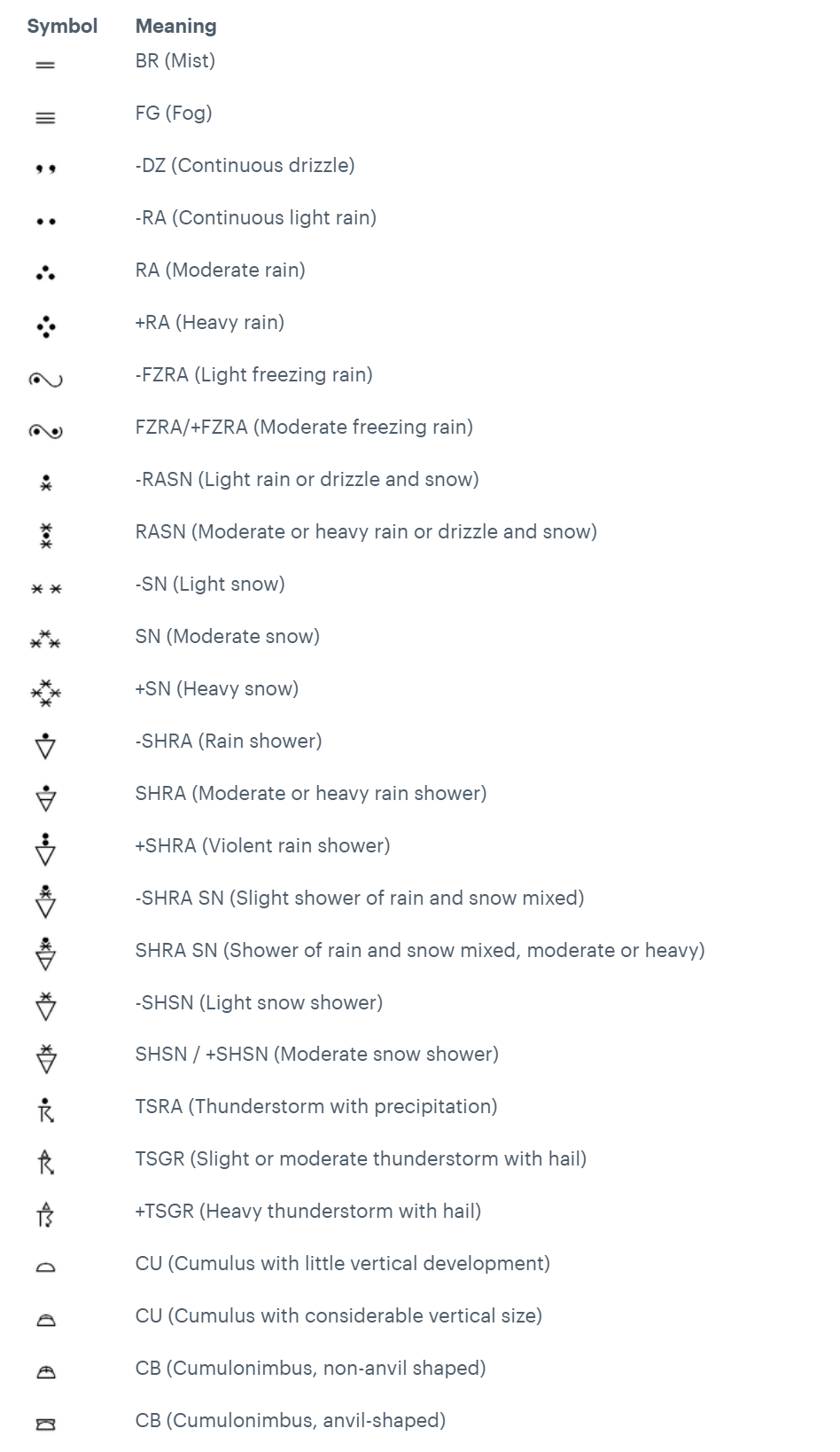
Weather symbols.
The symbols used by EasyVFR to display weather information on the map are mostly standard and internationally used symbols; however, the cloud base symbols are not. Below is an overview of all symbols used.
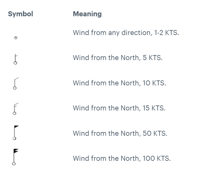
- Wind symbols.
EasyVFR uses the conventional wind barb symbols to display the winds at altitude. A wind barb consists of a pole and a flag, whereby the pole indicates the wind direction and the flag gives the wind speed.
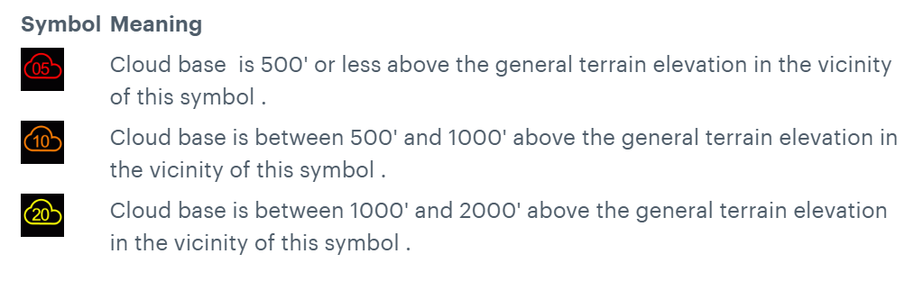
- Cloud base symbols.
The Cloud base symbols are not internationally defined. EasyVFR uses the following:
- SIGMET symbols.
These internationally used symbols for SIGnificant METeorological information are used by EasyVFR: