NOTE: This article is currently in progress. If something is missing or not clear, please reach out to support team using the blue "Ask the team" button at the bottom right of this page and we will answer you in a working day and update the article.
On this page:
Pre-Flight Preparation and Key UI elements
Ensure you and the app are ready for departure.
Initial Checks & Setup
Status Card: Check the status card (bottom right red/yellow/green button) for a quick overview of app configuration and data validity (AeroData, Weather, NOTAMs). It alerts you with color codes (Green/Orange/Red) if any action is required before flight.
Automatic Downloads: Keep essential data (NOTAMs, METARs, TAFs, etc.) up-to-date. Configure automatic updates or force ad-hoc updates via the Downloads Menu.
Aircraft Profile: Configure your aircraft's performance parameters, speeds, and perform mass & balance calculations for accurate flight planning and performance predictions.
Understanding the Interface
Familiarize yourself with core elements.
Map Presets: Quickly switch between Navigation, NOTAMs, and Weather map views using the top tabs in the Map Layers menu.
Info Sheet
Single Tap on Map - Instantly access information on any map element with a single tap. Whether it's airfields, navigational aids, airspace labels, or NOTAM centers, EasyVFR will predict the type of information you need based on your zoom level, previous actions, and whether you're planning a route or currently in flight.
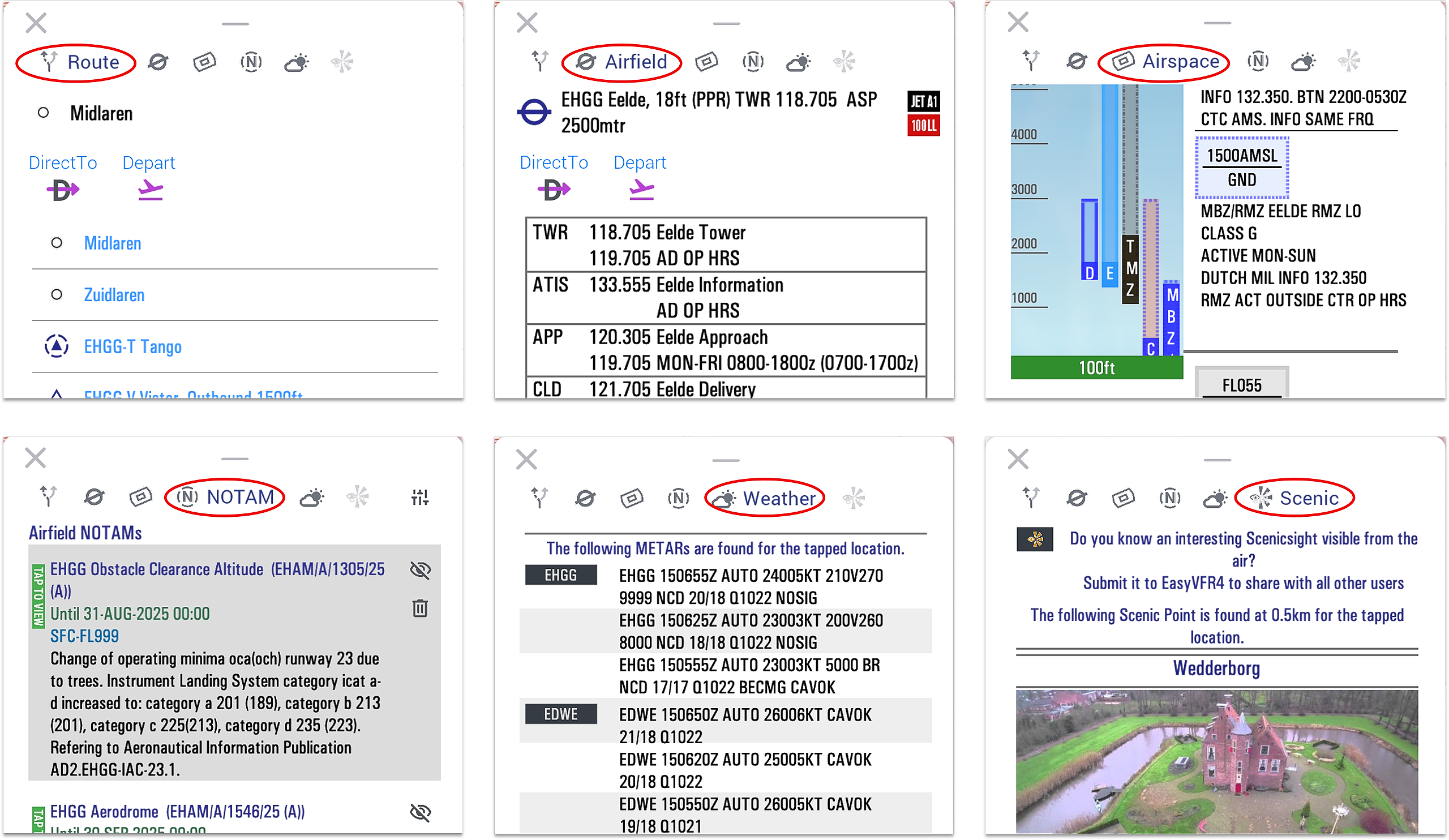
Switch Sheet Category - Effortlessly switch between info sheet categories using the icons at the sheet's header. This feature allows you to quickly select a different category if EasyVFR predicts the wrong one, or if you want to inspect all the available information for a specific location.
The available info sheet categories are:Route: User Waypionts Places and AeroData objects like Navaid's, Reproting points and Airfields around postion to add to your route.
Airfield: Most nearby airfield to on mapselected position.
Airspace: Airspace information and restrictions for teh exact on map selected position.
NOTAM: NOTAMs for the exact on map selected position.
Weather: METAR's and TAF's nearby on map selected position.
Scenic Sight: Points of interest and scenic locations for the exact on map selected position.
Sheet Height - Adjust the info sheet size by tapping or dragging the horizontal handler at the sheet's header.
Key UI Elements for Route
Learn core components like:
Leg Labels - Show direction, time, distance, altitude per leg.
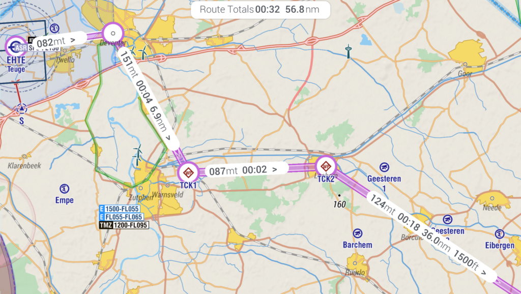
Route Totals - When route is active a tappable Bubble is shown on top of the map indicating the total/remaining time & distance.
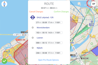
Route Card - Tap Route Totals for waypoint list & details.
Route Colors (Yellow = editing, Magenta = active).
👉 See the Route Planning guide for full details.
Checking Daily Flight Information
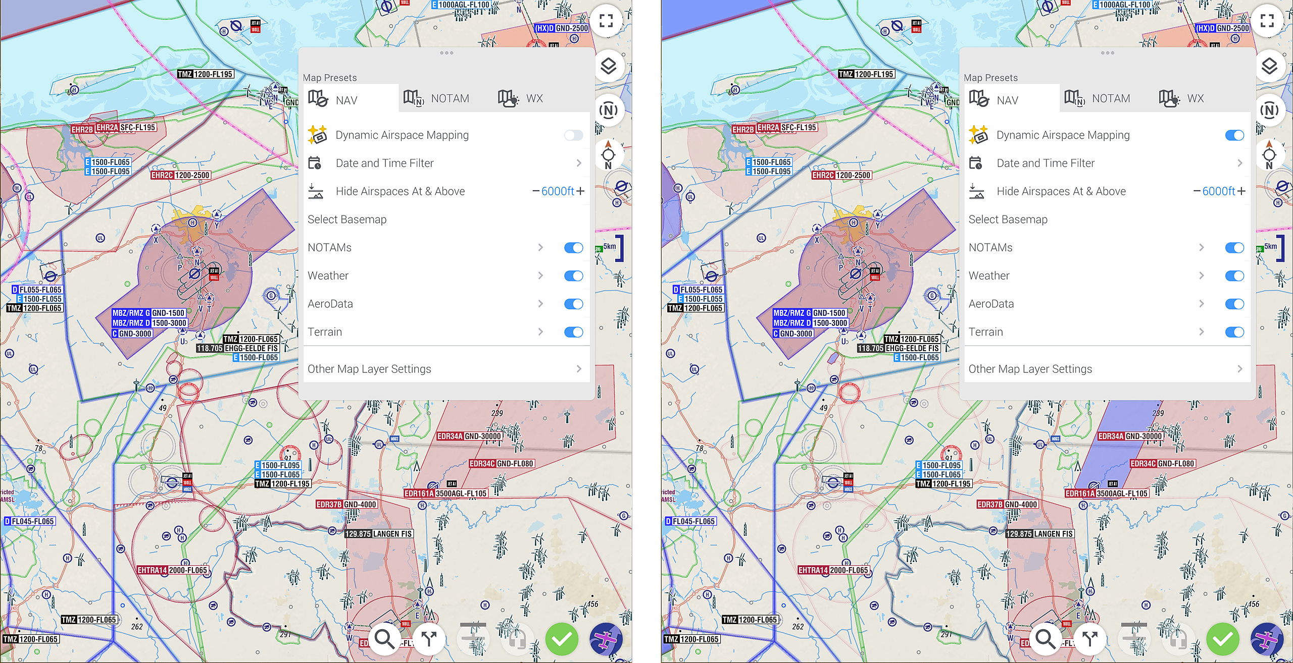
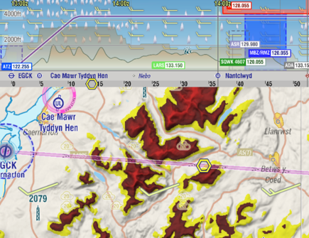
Dynamic Airspace Mapping (Live/Pro/FFM): Enhance situational awareness by visualizing the current airspace picture based on NOTAMs, AUPs, SUPs, etc. Fades inactive airspaces and highlights active ones. Understand how to set the timespan and how the mapping works.
Without Dynamic Airspace Mapping (left) vs. With Dynamic Airspace Mapping (right)
NOTAM Briefing: Obtain a comprehensive NOTAM briefing for your planned route or local flight area to stay informed about relevant notices.
Route Planning & Sharing
Master creating and editing routes using various methods.
Complete Route Planning Guide: Covers flexible workflows like map tapping and rubberbanding for all licenses and step-by-step menus ( for Pro/FFM licenses), automatic routing (Pro/FFM ), text input (Pro/FFM), or importing files (Pro/FFM).
Learn about Local Flights and managing User Waypoints.
Route Sharing Code: Share your planned routes with other EasyVFR users.
In-Flight Navigation & Tools
Utilize EasyVFR 4's tools for efficient and safe navigation while airborne.
Core Navigation & Monitoring
Planning vs. Flying Mode: Understand how the app transitions to Flying Mode (based on ground speed or manually) and adapts the display for in-flight use (remaining distances/times, map centering, etc.).
Map Orientation & View: Choose between North Up, Track Up, or Course Up map orientations (via compass icon). Learn how the map automatically re-centers on your position after panning.
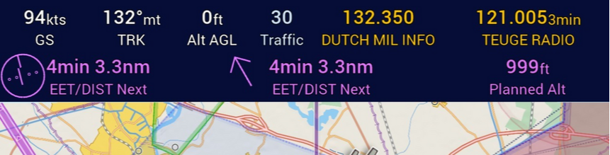
Instrument Ribbon: Monitor essential flight data (Ground Speed, Altitude, Track, etc.) at a glance. Customize the ribbon (tap an instrument) to show the instruments you need. Show/hide via Display button or Preferences.
Live Track Display: See your flown track plotted as an orange line (last 60 mins displayed in-flight to reduce clutter).
Situational Awareness Tools
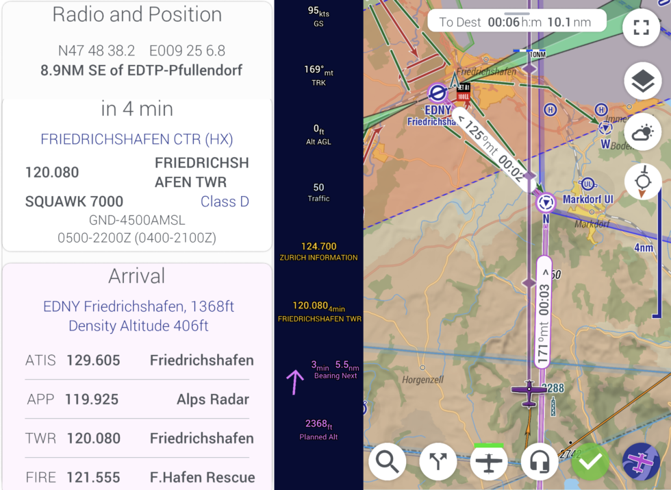
Radio and Position Card: Tap 🎧 (bottom bar) for quick access to departure/arrival/enroute frequencies and current/upcoming airspace info (), including activation status (Live/Pro/FFM).
Airspace Warnings: Receive visual and audible alerts to prevent infringing on restricted airspace.
Terrain Awareness: Utilize features like Relative Terrain coloring (shows terrain near/above you in Red/Yellow) and the Vertical Profile display (shows terrain below track and highest nearby) to maintain safe altitudes.
Navigating Airports
Airport Information: Navigate airport environments easily.
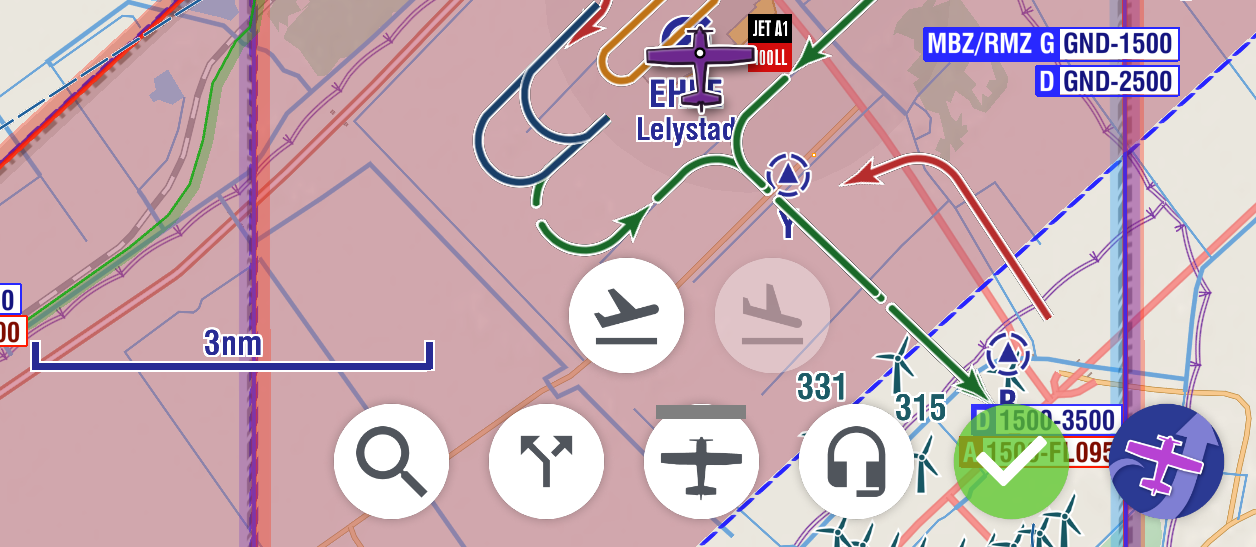
VFR Airport Routes & Traffic Patterns: The Airport Information Layer (AIL) displays essential VFR routes and patterns directly on the map for many airports.
VFR Airport Plates (Pro/FFM): View georeferenced VFR airport plates and visual approach charts directly on the moving map for streamlined approach procedures.
Post-Flight Analysis
Review your flight data after landing.
Reviewing Your Flight
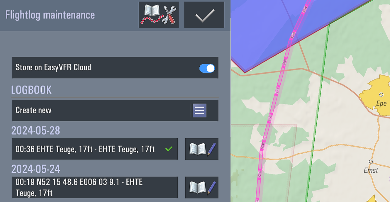
Flight Log & Analysis: Access the automatically recorded flight log via Flight Log Maintenance (Menu -> Flight Log Maintenance -). Review flight statistics, edit entries, sync to the cloud (optional), view track on map, and export your track data (GPX, CSV, Google Earth). Understand the difference between logbook entries and raw Track Logs.
Other Tools & Integrations
Explore additional capabilities.
Practice with Simulators
Flight Simulator Integration (Live/Pro/FFM): Connect EasyVFR 4 to X-Plane, Prepar3D, MSFS 2020/2024, or FSX for practice using real charts and procedures.
Traffic Awareness
(Electronic Conspicuity): Increase awareness of other aircraft.
SafeSky Internet Traffic: Enhance traffic awareness by integrating with SafeSky to display internet-based traffic information on the map (requires data connection).
uAvionix SkyEcho2 Integration: Connect your SkyEcho2 device to receive and display ADS-B traffic directly within EasyVFR 4.
Most other GDL90 / FLARM compatible devices may also be supported when your EasyVFR 4 device is in the same Wi-Fi network as your receiver.
This guide provides a starting point for using EasyVFR 4. Explore the linked articles for more in-depth information on each feature. Happy flying!