Table of Contents
What is GPS AeroData?
GPS AeroData is a comprehensive database containing airspace, NOTAMs, and customized information. It is updated every 15 minutes between 03:00 and 20:00 UTC for European countries. The database is compatible with flight computers, handheld navigation devices, and flight planning software using the CUB-format. The data is sourced from the European AIS Database (EAD) maintained by Eurocontrol and supplemented with special arrangements or procedures not listed in AIPs.
Data Types Included
Airspace: Various types of airspace with specific restrictions and requirements, varying by country or region.
NOTAMs: Over 180 types of NOTAMs are filtered to include only those relevant to gliding.
Customized Data: Special arrangements between aero clubs and authorities to accommodate gliding.
The data is filtered for relevance to gliding, encrypted, converted to the CUB-format, and then made available for download by pilots.
How it Works
Compatible devices
LXNAV
LX8000 Series
LX8000s with serial number lower than 25700 or from 27000 up to and including 27999 require an upgrade of the CPU.
LX80X0, and LX90X0 Series (all versions compatible)
Naviter
Oudie SeeYou Mobile Models: Oudie 2, 3, 4, and IGC are compatible.
Note: The new Oudie N and Navigator App are not yet compatible.
General Installation Instructions
Subscribe to GPS AeroData: Activate your subscription to download databases updated between 03:00 UTC and 20:00 UTC. Subscribe to GPS AeroData
Register Serial number(s): The database can only be used in systems or software with registered serial numbers. Up to 2 devices can be registered.
Download and Upload Database: The database file (CUB-format) must be uploaded to your system or software, which must be registered with serial numbers.
CAUTION: GPS AeroData is a daily Airspace and NOTAM build. Make sure to remove or deselect old data files!
Installation and Usage for LX80X0 and LX90X0 Series
Installation on LXNAV
Copy the database to an SD-card or USB-stick.
If you have the optional WiFi module, you can also load the current database directly from the internet to your registered flight computer.
Insert the card/stick into the registered flight computer.
Navigate to “Files and Transfer” > “Airspace (and NOTAMs)” in the Setup menu.
Load and activate the database, ensuring old databases are removed or deselected.
CAUTION: Make sure you remove or deselect old databases!
TIP: Check the settings under “Graphics” > “Airspace (and NOTAMs)”
Usage on LXNAV
There are three main pages available to manage NOTAMs on LXNAV devices:
Load and Activate Databases: Setup menu -> Files and Transfer -> Airspace (and NOTAMs)
Use this page to load and activate the latest GPS AeroData databases.Manage Appearance of NOTAMs: Setup menu -> Graphics -> Airspace (and NOTAMs)
Customize how NOTAMs appear on the moving map, including settings for font, color, zoom level, and border width.Search and Display Individual NOTAMs: Main menu -> NOTAM
Enter the Main menu from any map page by pressing any push button or the "enter" button/joystick on the remote stick, then navigate to [More>>] -> [More>>] -> [NOTAM]. This allows you to search, display, and read individual NOTAMs. You can sort, filter, show, and hide NOTAMs based on relevancy to the intended flight area or planned task.
Installation and Usage for Oudie 2, 3, 4, and IGC
Installation on Oudie
Upload the database to your Oudie using a micro SD-card or directly to the Oudie’s root (TFAT).
Run SeeYou Mobile and navigate to “Menu” -> “Settings” > “Files”.
Ensure “GPSAeroData” is checked under NOTAMs and Airspace.
Customize graphical display settings for NOTAMs and modify filter settings under “Menu” -> “NOTAMs” -> “Filter…”.
CAUTION: Make sure you remove or deselect old databases!
For additional guidance, refer to Naviter's own Knowledge Base:
Usage on Oudie
Recognize Database: System will automatically recognize the database.
Verify GPS AeroData: Menu > Settings > Files
Customize Graphical Display: Menu > Settings > Airspace
Check and Modify Filter Settings: Menu > NOTAMs > Filter…
More information is listed Naviter's own Knowledge base:
Finding Serial Numbers
The GPS AeroData .cub file can only be used in systems or software with registered serial numbers. Up to two devices can be registered on the same subscription and EasyVFR account. Register the serial numbers at My account / Avionics data - easyvfr4.aero.
LXNAV Serial Number:
Guidance on locating serial numbers for compatible systems, including LXNAV and SeeYou devices.
Switch on your LX80X0 or LX90X0.
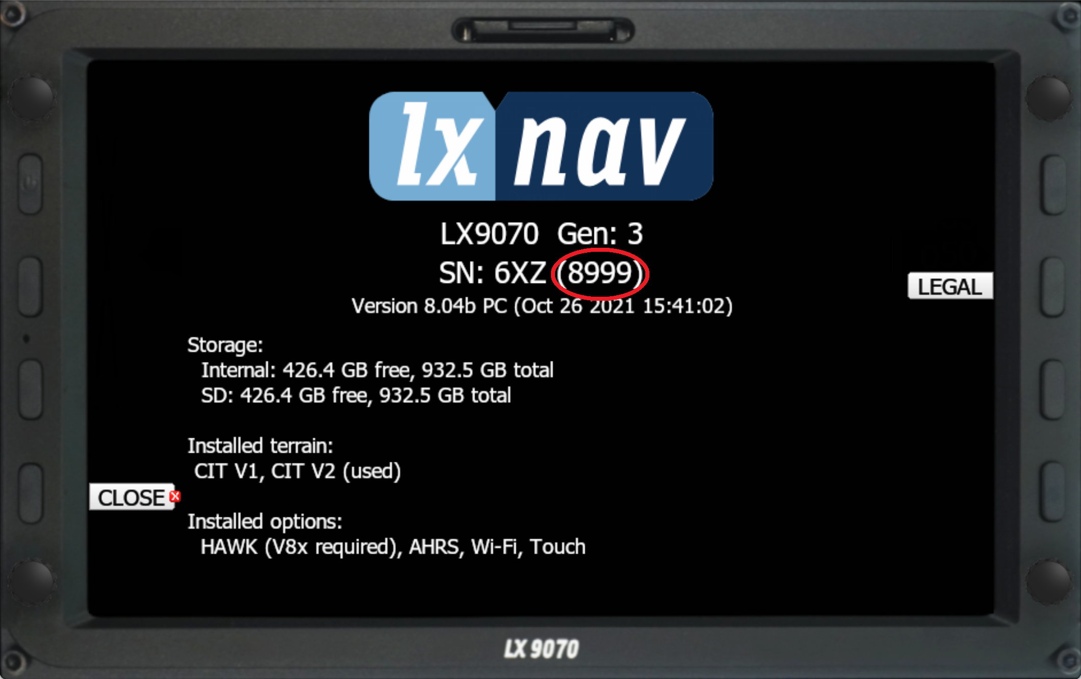
Go to the "Setup" and select [About].
Find the 4- or 5-digit numerical serial number between brackets.
Alternatively, check the sticker at the back of the flight computer.
Oudie Serial Number:
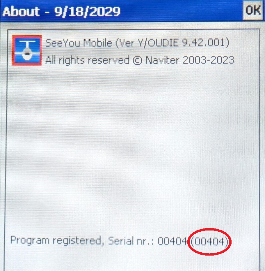
Switch on your Oudie and start SeeYou Mobile.
Go to [Menu] -> [Next>] -> [About].
Find the 5-digit numerical serial number between brackets.
Alternatively, when connected to your SeeYou account, find the serial number at My Devices - seeyou.cloud.
Trial in LXSim
You can download a trial version of GPS AeroData specifically designed for the LX9070 model in the LXNAV simulator "LXSim". This trial dataset is outdated and not suitable for navigation; it is built for testing purposes only. The trial file is configured for the LX9070 in the simulator with the serial number 8999.
Download and Select SD Card
Follow these steps to test the functionality and features of GPS AeroData within the simulator environment:
Download LXSim: Get the simulator from the LX Sim • LXNAV Gliding website.
Download the trial CUB file: Trial GPS AerData Cub File for LXSIm 9070.
Select a SD Card:
Open the LX Simulator and click on the SD card slot graphic.
Select the directory where the CUB file is located.
Usage in LXSim
To copy or load the file, follow the standard LX workflow to load the data from the SD card as described in the Installation on LXNAV section of this article.
Countries Covered
List of European countries included in the GPS AeroData database:
Albania
Armenia
Austria
Azerbaijan
Belgium
Bosnia and Herzegovina
Bulgaria
Croatia
Cyprus
Czech Republic
Denmark
Estonia
Finland
France
Georgia
Germany
Greece
Hungary
Iceland
Ireland
Italy
Latvia
Lithuania
Luxembourg
Malta
Moldova
Monaco
Montenegro
Netherlands
Norway
Poland
Portugal
Romania
San Marino
Serbia
Slovakia
Slovenia
Spain
Sweden
Switzerland
The Former Yugoslav
Republic of Macedonia
Turkey
Ukraine
United Kingdom